Photovoltaics power remote sensing stations for geosciences
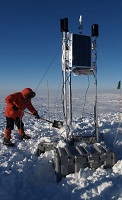 Since the 1990s, photovoltaics have been used by UNAVCO, formerly the University Navstar Consortium, to power remote sensing stations providing crucial geoscience data throughout the world, including stations at the earth’s extremes, the north and south poles.
These remote sensing stations send information back to UNAVCO on a daily basis, which it collects and disseminates to partnering organizations, universities doing research with the National Science Foundation, NASA and other scientific organizations. The sensing stations, which include ground-penetrating radar (LiDAR), global positioning sensors (GPS), other sensors and transmitters, are powered by photovoltaics, said Bjorn Johns, a UNAVCO project manager, who works on polar research projects.
The photovoltaic sensing systems are designed for remote use and continual operation.
“[They’re placed] as far as you can possibly go. We have stations on the northernmost and southernmost parts of the world. Places like Greenland, Antarctica,” Johns said. Some sensors are close to the South Pole. “Someone may not lay eyes on them for years.”
And servicing these remote stations may require the use of icebreaking boats or helicopters. The systems have to be designed for performance.
“We have such limited maintenance opportunities,” he said.
The list of research projects that UNAVCO’s remote stations have contributed data to are extensive, according to Johns.
For instance, NASA uses UNAVCO data to provide more accurate GPS information for satellites.
“They’re more involved in operational GPS to get better positions for spacecraft orientation. What they’re involved in is essentially providing enhanced data products for satellite feed operations,” he said.
The remote sensing stations are also used to provide information about climate change at the poles.
“There’s just so much more data out there about how the world is moving,” he said, “a whole new understanding of ice sheet dynamics and how the ice sheets have flown at the poles.”
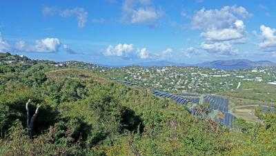
But they’re not just located in the remotest locations on the earth.
Following the tragic earthquake in Haiti last year, UNAVCO began locating new remote sensing stations throughout the equatorial region.
“There’s a whole project putting a ring of stations around the Caribbean,” Johns said.
According to Johns, these sensing stations are helping scientists better understand what’s happening with the tectonic processes of the earth. While Johns said it’s far away, such sensing stations could, in the future, be used to help with earthquake prediction.
At present, the data can be used to show which regions are at risk, he said.
Image courtesy of UNAVCO.